Surface and Canopy Fuels in the 2022 CO-WRA Update
Authors
Kyra Czerwinski, GIS Technician, Colorado State Forest Service
Nicholas Kotlinski, Geospatial Data and Analysis Program Manager, Colorado State Forest Service
Editors
Amanda West Fordham, Associate Director, Science and Data Division, Colorado State Forest Service
Field Peterson, Forestry Communications Specialist, Communications and Communities, Colorado State Forest Service
Introduction
The Colorado Wildfire Risk Assessment (CO-WRA) is a statewide geospatial analysis designed to increase wildfire awareness, provide comprehensive data and information concerning wildfire risk and local fire history and educate users about wildfire risk reduction and hazard mitigation resources available from the Colorado State Forest Service (CSFS) and partner organizations. The CO-WRA dataset is updated on a five year cycle with each version dated according to the year in which the data was collected.
The 2022 CO-WRA update was released on July 17, 2023. This update provides finer spatial resolution fire behavior and risk products, increasing the utility of the data to community-level planning compared to the previous CO-WRA. The CO-WRA 2022 project was managed by the CSFS, and experts with the agency contributed to field data collection as well as the development of both fuels and fire behavior modeling. All data processing, fire modeling and documentation were provided by Technosylva Inc. researchers and staff.
All data and information related to CO-WRA can be found in the Colorado Forest Atlas. The Forest Atlas offers two applications where users may access and download the CO-WRA data: The Wildfire Risk Viewer, which is designed for use by the public, and the Wildfire Risk Reduction Planner, which is designed to support the needs of government officials, hazard-mitigation planners and wildland fire professionals.
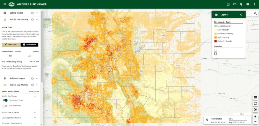
Figure 1a: The Wildfire Risk Viewer application allows users to identify specific wildfire risk levels within a half-mile radius of a home, or any other point of interest on the map. A risk level description and link to additional resources is provided for users wanting to know how to reduce their risk. The Wildfire Risk Viewer can be accessed with no account required from the Colorado Forest Atlas (https://coloradoforestatlas.org/).
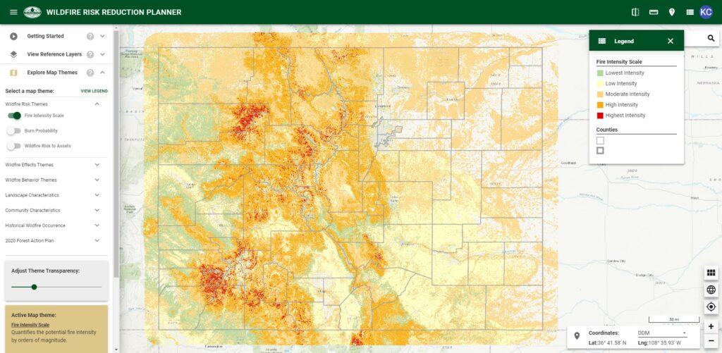
Figure 1b: The Wildfire Risk Reduction Planner application. Designed to provide community wildfire protection planning support for government officials, hazard-mitigation planners and wildland fire professionals across the state. The Wildfire Risk Reduction Planner can be accessed by creating a free account for the Colorado Forest Atlas (https://coloradoforestatlas.org/).
Fuel Models in the 2022 CO-WRA Dataset
A key feature of the 2022 CO-WRA dataset is the updated fuels modeling for both surface and canopy fuels. These fuels models compute surface fire behavior characteristics, such as rate of spread, flame length, fireline intensity and other fire behavior metrics. Surface fuels account only for surface fire potential, while canopy fire potential is computed through a separate but linked process. The CO-WRA includes both surface and canopy fire potential in the fire behavior outputs.
What Is a Fuel Model?
A fuel model consists of vegetation groups with similar physical characteristics that contribute to the spread, intensity and severity of wildland fires. These characteristics reflect loading, size and bulk density of vegetation. The CO-WRA analysis uses and expands on the 40 fire behavior fuels models established by Scott & Burgan (2005), a nationally recognized standard for fuels modeling.
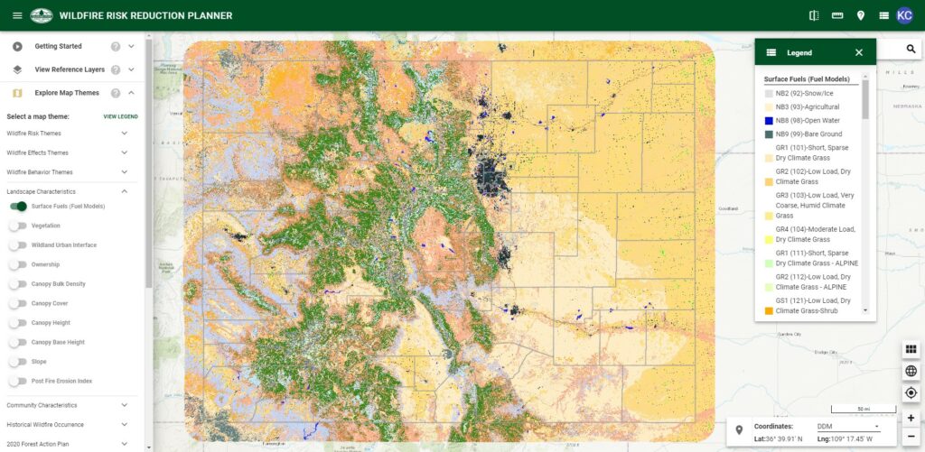
Figure 2: The surface fuels model in the 2022 CO-WRA dataset includes categorizations based on the Scott & Burgan Fire Behavior Fuel Model (Scott & Burgan, 2005), with some additional disaggregation and custom fuels modeling for the Colorado landscape.
How Are Fuel Models Derived?
Fuels modeling involves the use of satellite data and imagery in combination with technical analysis to produce detailed categorizations of vegetation across the landscape. The 2022 CO-WRA project relied on Colorado fuels experts and CSFS forester support in field data collection and validation, or “ground truthing” data for the updated fuels models to improve accuracy of remotely derived fuels models. Additional technologies like LiDAR (“laser imaging, detection and ranging”) and machine learning are also used in the CO-WRA update to improve accuracy, increase spatial resolution and fill in gaps in existing data where necessary.
A common and standardized source for fuels modeling at the national level is the Landscape Fire and Resource Management Planning Tools (LANDFIRE) program, a dual wildland fire management program between the U.S. Department of Agriculture Forest Service and the U.S. Department of the Interior. The LANDFIRE program utilizes the USFS Forest Inventory and Analysis (FIA) Program to conduct ground truthing across the country (Vogelmann et al., 2011).
The analysis team for the 2022 CO-WRA dataset used LANDFIRE fuels models as reference during the validation process, making strategic technical and statistical adjustments to the LANDFIRE methodology to integrate high elevation wildfire behavior that has been observed in Colorado since the previous CO-WRA (e.g., East Troublesome Fire) in order to best represent Colorado’s unique landscape conditions.
Differences Between 2017 and 2022 CO-WRA Fuel Models
The 2017 CO-WRA dataset used LANDFIRE as the primary source for fuels data, which is derived from Landsat imagery at a 30-meter resolution. The 2022 CO-WRA establishes a new fuels model for Colorado, incorporating higher resolution imagery (20 meters, Sentinel-2 imagery), LiDAR, custom fuels models for surface fuels and machine learning for canopy fuels (Table 1). The newest available LANDFIRE data was used to compare and validate the 2022 CO-WRA fuels model during the analysis process.
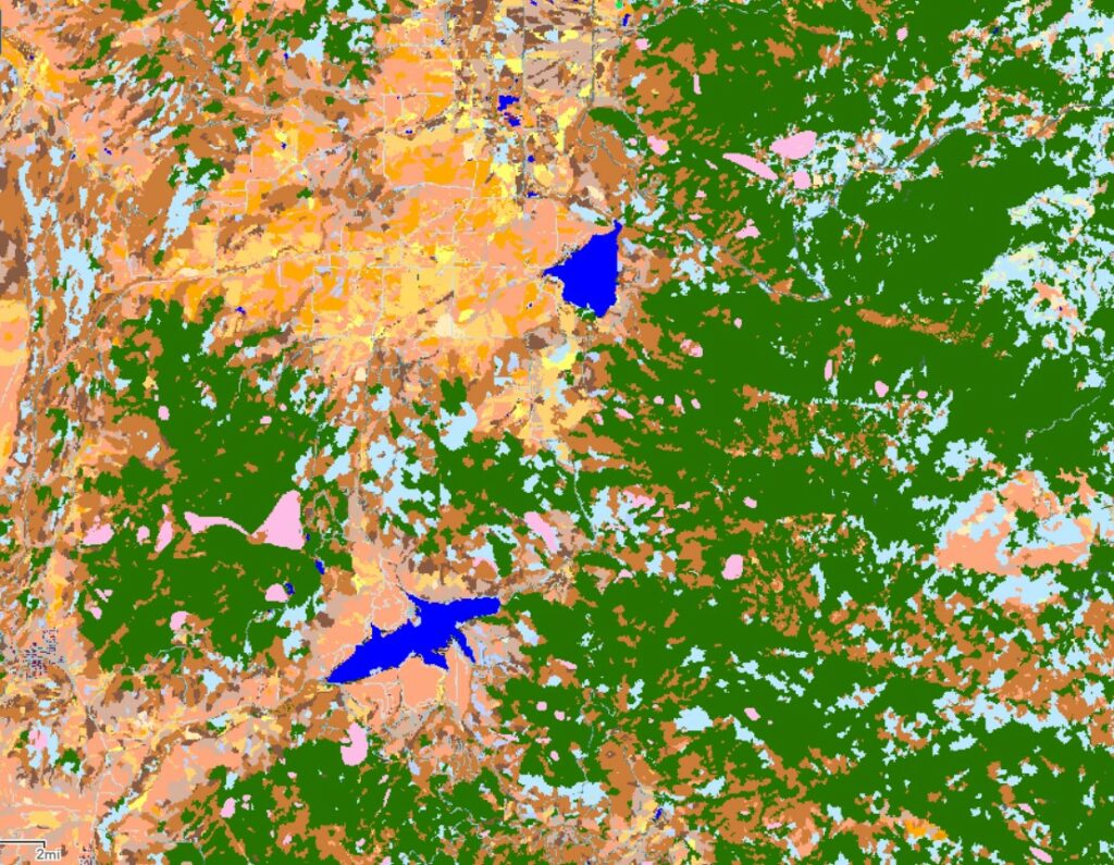
Unlike LANDFIRE and other pixel-based analyses, the updated CO-WRA fuels layers were categorized using OBIA (Object Based Image Analysis) (Figures 3a & 3b). OBIA uses polygons, rather than pixels, to assign fuel models based on homogenous vegetation areas. This approach recognizes that the vegetation type of a single pixel is not as relevant to fire behavior and fuel distribution as the characterization of a polygonal area, where the distribution of the multiple vegetation types within the area can be analyzed together to provide more accurate representation of how fire may behave as it moves through the landscape.
2022 CO-WRA
2017 CO-WRA
Resolution
20 meter
30 meter
Assessment Scale
Building-Level Metrics
Community-Level Metrics
Surface Fuels
Imagery + LiDAR + Custom Fuels
LANDFIRE
Canopy Fuels
Imagery + LiDAR + Machine Learning
LANDFIRE
Table 1: Comparing resolution, scale and fuels modeling in the 2017 CO-WRA and the 2022 update.
Figure 3a: Pixel-based analysis from LANDFIRE from the 2022 CO-WRA.
Figure 3b: Object Based Image Analysis (OBIA) from the 2022 CO-WRA.
2022 CO-WRA Surface Fuel Models
The surface fuels model for the 2022 CO-WRA uses the Scott & Burgan fuels models as a foundation, a nationally recognized standard for fuels modeling (Scott & Burgan, 2005). The Scott & Burgan family contains 40 fuel models distributed in seven fuel model groups:
Non-burnable Fuel Type Models (NB– 90)
Grass Fuel Type Models (GR or 100)
Grass-Shrub Fuel Type Models (GS or 120)
Shrub Fuel Type Models (SH or 140)
Timber Understory Fuel Type Models (TU or 160)
Timber Litter Fuel Type Models (TL or 180)
Slash-Blowdown Fuel Type Models (SB or 200)
To improve on these categories for the 2022 CO-WRA dataset, two new categories of timber understory (TU) fuel models were developed. Rate of spread (ROS) is often under-predicted in Scott and Burgan fuel types. To simulate fire behavior closer to what is expected in Colorado, especially higher elevation forests, custom timber fuel types were developed based on measure fire behavior from recent high elevation fires, using machine learning algorithms and observed fire behavior from over 1,800 fires.
TUML1 (171): Timber Understory Dynamic ML4
TLML1 (191): Timber Litter ML.
The analysis team at Technosylva also conducted a disaggregation of urban, roads, agriculture and water layers in the Non-Burnable Fuel Type Models group to further refine layers in the wildland-urban interface (WUI).
The final surface fuels layer was developed by combining the fuel model groups from Scott & Burgan and the custom fuels models by Technosylva. Use the swipe tool in the interactive map below to compare the CO-WRA surface fuel layers from 2017 and 2022.
Figure 4: Interactive web map showing the 2017 and 2022 CO-WRA surface fuels layers. Click and drag the swipe tool to compare the layers.
2022 CO-WRA Canopy Fuel Layers
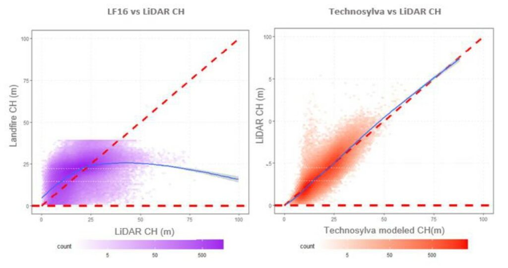
Several canopy metric layers were generated using LiDAR information and optical imagery for Colorado to simulate crown fire behavior later in the risk assessment analysis. A machine learning algorithm developed by Technosylva was used to predict the canopy layers in areas where LiDAR was not available. This methodology showed a significant improvement from LANDFIRE canopy layers when compared to available LiDAR data.
Figure 5: LiDAR Canopy Height prediction comparison of LANDFIRE (left) and Technosylva (right).
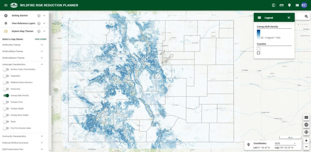
The canopy fuel layers in the 2022 CO-WRA include:
Canopy Height (CH)
Canopy Cover (CC)
Canopy Bulk Density (CBD)
Canopy Base Height (CBH)
These fuel groups were used to inform the surface fuels models in the 2017 CO-WRA dataset; however, the 2017 release did not include a standalone canopy fuels layer in the final products. The 2022 CO-WRA offers individual map layers to represent each of these listed categories.
Figure 6: Canopy Bulk Density (CBD) layer in the 2022 CO-WRA.
Conclusion
CO-WRA 2022 provides updated state-wide surface fuels, canopy fuels and fire characteristic metrics, and has provided these datasets at an improved spatial scale from previous analyses. The use of LiDAR, machine learning and higher resolution satellite data has allowed the CSFS to provide outputs at greater detail than ever before. Improved custom fuels models also advance static and dynamic fire modeling and provide a starting point for partners and practitioners to incorporate the data into their own analyses. Finally, to support the mission of the Colorado State Forest Service “To achieve stewardship of Colorado’s diverse forest environments for the benefit of present and future generations”, this enhanced data is made accessible through the Colorado Forest Atlas website, to provide neighborhoods and communities with the best available landscape and fire information possible.
The Colorado Forest Atlas provides user-specific functionality to support professionals and members of the public, allowing users to view CO-WRA layers, download data and run reports for areas of interest using the Wildfire Risk Viewer and Wildfire Risk Reduction Planner web applications. The Wildfire Risk Reduction Planner provides analysis capabilities critical to supporting project implementation and grant applications for partners, researchers and communities across Colorado.
References
Blaschke, T. 2010. Object based image analysis for remote sensing. ISPRS Journal of Photogrammetry and Remote Sensing. Volume 65, Issue 1. ISSN 0924-2716. https://doi.org/10.1016/j.isprsjprs.2009.06.004.
Rothermel, R. C. 1972. A mathematical model for predicting fire spread in wildland fuels. Res. Pap. INT-115. Ogden, UT: U.S. Department of Agriculture, Forest Service, Intermountain Forest and Range Experiment Station. 40 p.
Scott, Joe H.; Burgan, Robert E. 2005. Standard fire behavior fuel models: a comprehensive set for use with Rothermel’s surface fire spread model. Gen. Tech. Rep. RMRS-GTR-153. Fort Collins, CO: U.S. Department of Agriculture, Forest Service, Rocky Mountain Research Station. 72 p
Vogelmann et al. 2011. Monitoring landscape change for LANDFIRE using multi-temporal satellite imagery and ancillary data. IEEE Journal of Selected Topics in Applied Earth Observations and Remote Sensing. 252 – 264. 10.1109/JSTARS.2010.2044478.