

Forest Types
Forest Types Overview
Forest type, or forest cover, refers to the dominant tree species in the overstory of a given site. The distribution of forest types across the landscape is determined by factors such as climate, soil, elevation, aspect and disturbance history (Rogers, et al, 2001)3. A number of Colorado’s forests are characterized as disturbance driven. The life history of these forest types evolved with a cycle of natural disturbance such as wildfire, insect infestations, flooding, avalanches, windstorms or disease infections. These disturbances served to periodically rejuvenate forests, ensuring a variety of forest types, age classes and densities across the landscape.
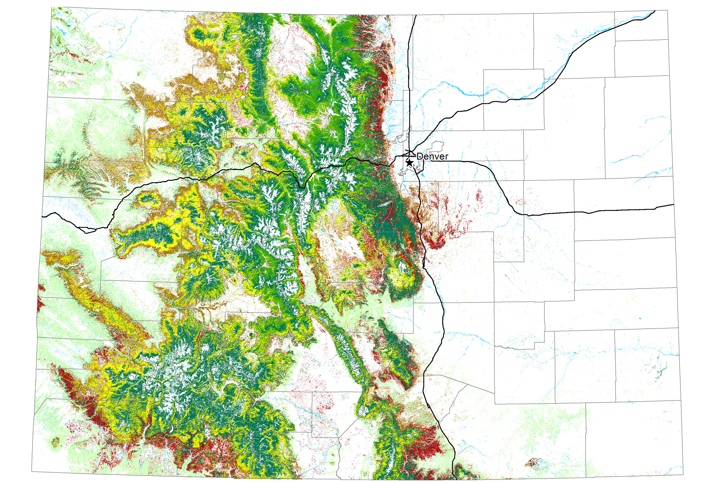
Forests and woodlands cover approximately 24 million acres in Colorado. Within these forested landscapes are several different tree species, the majority of which are coniferous or cone-bearing trees rather than deciduous trees that seasonally shed their leaves. Colorado’s primary forest species have been grouped into 10 forest types based on the dominant overstory vegetation (Helms 1998)4: conifer, conifer-hardwood, hardwood (primarily aspen), lodgepole pine, mixed conifer, oak shrublands, piñon-juniper, ponderosa pine, riparian and spruce-fir.
Follow the links for brief descriptions of these forest types.
Ecoregions in Colorado
The basis for this vegetation mosaic is a physical landscape that ranges from plains and high plateaus to steep mountains, deep canyons and sloping foothills. A wide range of topographic, soil and growing conditions further influences this variety and contributes to the state’s multi-faceted forest resources.
Issues and events that influence forest condition often occur across forest types, ownerships and political boundaries. As a result, scientists, researchers and land managers must also find a way to assess and treat these issues in a boundaryless way. Ecoregions often are used as a non-political land division to help researchers study forest condition. An ecoregion is a large landscape area that has relatively consistent patterns of topography, geology, soils, vegetation, climate and natural processes (Shinneman et al 2000)1. Many smaller ecosystems may reside within an ecoregion.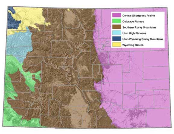
Colorado contains parts of six major ecoregions (Bailey 1995)2. The most prominent is the Southern Rockies, which occupies most of the state’s central and western portions and the Great Plains-Palouse Dry Steppe in the eastern half of the state. Other ecoregions include the Intermountain Semi-Desert and Desert, the Nevada-Utah Mountains and the Colorado Plateau. Forests are found in all ecoregions of the state, but the Southern Rockies contain the most forested area and the greatest variety of forest types.