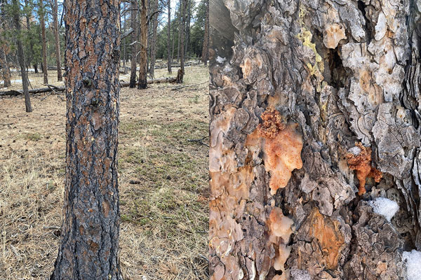
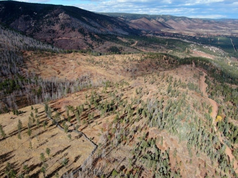
Franktown Field Office
The Franktown Field Office of the Colorado State Forest Service (CSFS) is one of 18 field offices throughout Colorado, serving Arapahoe, Douglas, Elbert and Lincoln counties. We are a service and outreach agency of the Warner College of Natural Resources at Colorado State University (CSU).
Our mission is to achieve stewardship of Colorado’s diverse forest environments for the benefit of present and future generations.
Staff
Spencer Weston – Supervisory Forester
Joe Gray – Lead Forester
Nathan Wallace – Forester
Currie Nowell – Forester
Mark Herbeck – Forester
News & Resources
March Is Good Time to Check for Mountain Pine Beetle – March 7, 2023
Ponderosa Pines, Spruce May Exhibit ‘Winter Burn’ Damage – April 26, 2020
PDF version (250 KB)
2024 Local Forestry Contractors (230 KB PDF)
Bark Beetle Identification Guides
Bark Beetle Inspector – Identification & Treatment Field Guide (5.5 MB PDF)
Mountain Pine Beetle (10.7 MB PDF)
Post-Fire Rehabilitation
- Aspen (939 KB PDF)
- Douglas-fir (586 KB PDF)
- Gambel Oak and Serviceberry (865 KB PDF)
- Piñon Pine-Juniper (888 KB PDF)
- Ponderosa and Lodgepole Pine (896 KB PDF)
Contact Information
PO Box 485
2068 N. State Hwy. 83
Franktown, CO 80116
(303) 660-9625; FAX (303) 688-2919
[email protected]
The office is north of the intersection of Highway 86 and Highway 83 in Franktown (see map below).
Partners
Rocky Mountain Regional Office (Golden)
Pike-San Isabel National Forest and Cimarron-Comanche National Grasslands
South Platte Ranger District
Chatfield State Park
Cherry Creek State Park
Castlewood Canyon State Park
Roxborough State Park
Arapahoe County
Douglas County
Douglas County Wildfire Mitigation Specialist
Elbert County
Lincoln County
Arapahoe County Extension
Douglas County Extension
Elbert County Extension
Lincoln County Extension
Double El Conservation District
Douglas County Conservation District
West Arapahoe Conservation District
Field Office Location
Forest Health Report Story Map
CSFS Forest Entomologist Dr. Dan West produced an Esri Story Map for the annual Forest Health Report, which offers users an interactive way to learn about local forest conditions.
Wildfire Risk Viewer
The Wildfire Risk Viewer is a web-mapping application that allows users to identify specific wildfire risk levels within a 1/2-mile radius of a home, or any other point of interest on the map.