Urban FIA
Urban FIA
Program information
The goal of the U.S. Forest Services’ Urban FIA program is to “assess the status and trends of trees and forests in urban settings, including the services they provide, their health, and future risk from insects and disease.”1 To accomplish this, Urban FIA crews conduct measurements at research plots in the “urban forest”, which are located within U.S. Census Bureau defined urban areas. Cities selected for sampling contain approximately 200 plots each. Other municipalities outside larger city boundaries will have less plots, which vary depending on population.
Urban FIA plots are located on private property, public property, open spaces, forests within city limits, and many other man-made or natural features. These plots are selected at random locations within a hexagonal grid, just like the Rural FIA process. CSFS staff have established Urban FIA plots in Denver, Front Range cities, Colorado Springs, Pueblo, and several other cities throughout Colorado.
Many cities conduct their own street tree and park tree inventories that are separate from the Urban FIA program. The data collected in the Urban FIA program includes areas that are typically missed in other inventories such as backyards, commercial building landscaping, golf courses, and along waterways.
Urban forest facts:
- Over 80% of the U.S. population lives in Urban Areas or Urban Clusters (UAUC)
- The total area of UAUCs add up to approximately 68 million acres – with an estimated 33% of this area (22 million acres) covered by trees
- Urban trees offer a range of environmental and social benefits, including:
- Reducing air pollutants
- Oxygen production
- Absorbing UV radiation
- Reducing noise pollution
- Reduction in vehicular traffic and speeding
- Improved property values
- Reducing human stress and mental fatigue
- Providing shade for buildings, which lowers energy costs
- Reducing the severity of flooding
The Urban FIA data collected throughout the U.S. is also incorporated into i-Tree2. This software suite, provided free of charge, offers tools for assessing the benefits of an individual tree and for trees within specific parcels, neighborhoods, cities, and entire states. There are also tools to help with site specific advice for tree species selection and planting. More information on i-Tree can be found in the Frequently Asked Questions section below.
Program history
The Agricultural Act (U.S. Farm Bill) of 2014 required the USDA to “implement an annualized inventory of trees in urban settings, including the status and trends of trees and forests, and assessments of their ecosystem service, values, health, and risk to pests and diseases.”2 The Forest Inventory and Analysis program began collecting data on “trees in urban settings” (a.k.a. the urban forest) that same year.
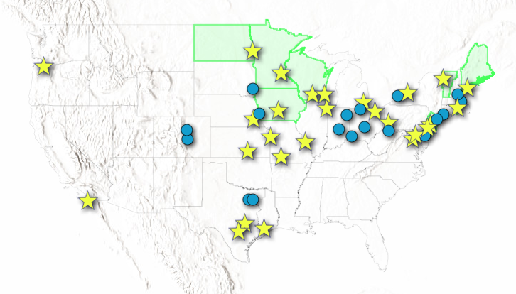
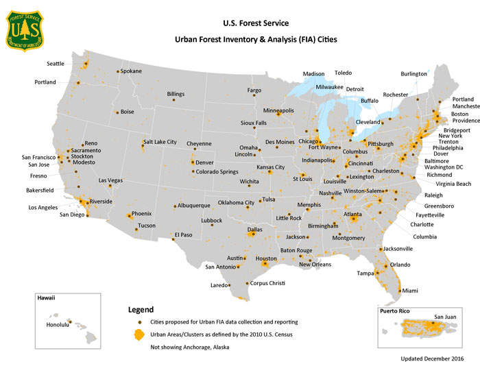
Urban FIA inventories are now conducted in over 40 cities, with further implementation planned to cover all urban areas across the nation (Figure 1)3. Since 2017, CSFS has collected Urban FIA data in Denver, Colorado Springs, and various other urban areas across the state.4 The first cycle of plot establishment will be completed by the end of 2027, with re-measurements of plots continuing every 10 years after initial establishment.
Data collection
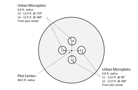
Urban FIA plots (see Figure 2) are often located within private property and CSFS Urban FIA crews request access from landowners to complete measurements at these plots. The amount of Agricultural Act of 2014, Subtitle D, Sec. 8301.b.2.: https://agriculture.house.gov/sites/republicans.agriculture.house.gov/files/pdf/legislation/agriculturalact2014.pdftime our crews will be on private property is dependent on several factors including: number of trees, ease of accessing the survey area, number of employees surveying the plot.
On average, Urban FIA plots in Colorado typically take ½ hour to 4 hours to complete. Some plots with a high number of trees within the 48ft radius plot make take longer than average.
Landowners do not have to be present during the data collection but are welcome to observe us working.
CSFS Urban FIA crews collect vegetation data, similar to the Rural FIA procedures, but also collect urban specific information that can be incorporated into i-Tree. We assess trees shading residential buildings (for energy savings), tree canopies cleared for powerlines, and damage to sidewalks or other infrastructure.
Frequently Asked Questions (FAQs)
What is the 'urban forest'?
FIA uses the term “urban forest” broadly, to refer to the tree canopy cover of an urban area, including trees and tall shrubs. FIA uses the U.S. Census Bureau definition of “urban area,” which includes Urban Areas and Urban Clusters (UAUC), to define the boundaries of the urban forest. Urban Areas have a population of 50,000 or more. Urban Clusters have at least 2,500 but fewer than 50,000 people. This definition was changed after the 2020 U.S. Census but is still used for the current Urban FIA program.
What is i-Tree?
i-Tree is a state-of-the-art, peer-reviewed software suite developed by a cooperative initiative of the USDA Forest Service. Partners in the initiative include: Davey Tree Expert Company, Arbor Day Foundation, Urban and Community Forestry Society, International Society of Arboriculture, Casey Trees, SUNY College of Environmental Science and Forestry, National Association of Foresters, and American Forests.
The software products of i-Tree allow property owners, communities, non-profit organizations, consultants, volunteers, and students to assess urban trees. i-Tree was first launched August 2006 and has allowed for a better understanding of the tangible ecosystem services that trees provide. There are now over 10 software tools available for assessing individual trees, canopy area assessments, and tree planting assistance.
For more information visit the i-Tree website.
Can you look at my tree that looks sick or is damaged?
We cannot provide advice for any damaged or “sick” trees while visiting an Urban FIA plot. We recommend that all trees on your property, that you are concerned about, be properly assessed by an ISA Certified Arborist. Street trees and other trees on public property should be assessed by your local city arborists or city foresters. CSFS Field Office staff can help you with this process.
Who will be conducting the data collection at my property?
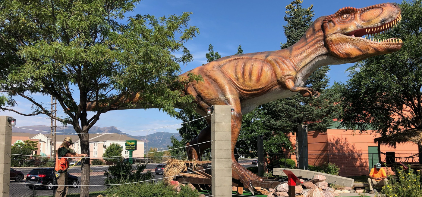
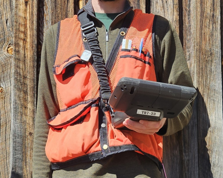
If you agree to have an Urban FIA data collection crew visit your property, a small crew of typically 1-3 people will visit at a time that is most convenient for you. A crew leader will communicate with you to ensure that all your questions are answered before, during, and after the visit. Crew members will bring with them all the tools necessary for measurements. Figure 3 shows an example of what an FIA crew member will bring with them to collect data.
Where can I get more information on Urban FIA?
The Urban FIA program combines the framework of the traditional, rural-focused FIA program with the urban inventory expertise provided by i-Tree. Using new methods and protocols specifically designed for urban environments, the program produces estimates of the quantity, health, composition, and benefits of urban trees and forests. The Urban FIA program works alongside existing regional and local efforts to create a comprehensive understanding of urban forest conditions across the U.S.1
Urban forest facts:
- Over 80% of the U.S. population lives in Urban Areas or Urban Clusters (UAUC)
- 68 million acres fall within UAUCs, with an estimated 33% of this area (22 million acres) covered by trees
- Urban trees offer a range of environmental and social benefits, including:
- Carbon dioxide removal and air pollution filtration
- Oxygen production
- Absorbing rainwater, UV radiation and noise
- Traffic calming and improved property values
- Reducing human stress and mental fatigue
- Providing shade for buildings, which lowers energy costs
Advantages
The advantages of conducting an inventory of urban forests include, but are not limited to:
- Provides strategic, city-wide data based on both public and private trees, helping leaders make informed decisions
- FIA’s strong reputation as a well-respected national program with a proven track record of success
- A robust partnership between the FIA and i-Tree programs, combining expertise from both fields
- Quality assurance/quality control protocols similar to those used in the core FIA program, ensuring reliable and consistent data
- Comprehensive data including volume estimations, species diversity, canopy cover and expanded land-use classifications
- Publicly accessible data via the Urban FIA DataMart, making information readily available for analysis and decision-making
- User-friendly interfaces such as the My City Trees App, which makes the data easily accessible to citizens and policymakers
- Timber Product Outputs (TPO) data providing insights into the wood merchantability of trees in urban areas
- Urban Woodland Owner Survey (WOS), which collects information on landowners and their urban forestry practices
- Certified professionals will conduct the annual inventories and remeasurements, ensuring consistency and accuracy over time
- Potential for broader analysis of regional or national trends in urban forests using a systematic, standardized methodology
These benefits help to strengthen urban forestry management, support sustainable tree care, and provide valuable insights for both local and national forest policy.
Examples
Economic value
A recent i-Tree analysis of Austin, Texas, estimated that trees save the city nearly $19 million annually by reducing building energy use. They also provide about $5 million in savings through reduced carbon emissions and are valued at around $16 billion as standalone physical assets. Beyond that, trees contribute $3 million per year by reducing air pollution (based on avoided respiratory health problems) and nearly $12 million per year in carbon sequestration.
Disturbance predictions
Urban FIA data, collected consistently over time, will play a crucial role in evaluating the impact of major disturbances. For instance, during the 2011 drought, approximately 5.6 million urban trees in Texas died—potentially 10% of the urban tree population in the region. By tracking Urban FIA data across metropolitan areas, we can assess the damage caused by future droughts or storms and monitor the long-term ecological recovery and resilience of urban forests.
Urban forest dynamics
In rapidly growing urban areas, Urban FIA data helps compare the urban forest in newly developed areas with older parts of a city. This insight allows urban forest managers to allocate resources efficiently, focusing on maintaining the health of older tree populations and establishing new urban forests to meet the needs of expanding cities.
Stormwater mitigation
Urban trees significantly help mitigate stormwater runoff by intercepting rainfall. Urban FIA data can provide leaf area estimates by region, species, and size class, allowing natural resource managers to calculate the stormwater interception capacity of urban trees within a watershed. For example, the San Antonio River Authority (SARA) used Urban FIA data collected in Austin, TX, to develop a standardized methodology for calculating the stormwater mitigation value of trees, helping to inform best management practices under San Antonio’s Tree Ordinance.
Policy impact
Research from the U.S. Forest Service on the benefits of New York City’s urban forest was instrumental in convincing Mayor Bloomberg to fund the MillionTreesNYC campaign, which successfully planted one million trees. Similarly, Urban FIA data will provide policymakers in communities across the U.S. with essential information to guide urban forestry policy and support tree planting and conservation efforts.
1USDA Forest Service. (2017, January 10). Urban Forest Inventory and Analysis (FIA). Retrieved from https://www.fs.fed.us/research/urban/fia.php.
Información Programática (200 KB PDF)